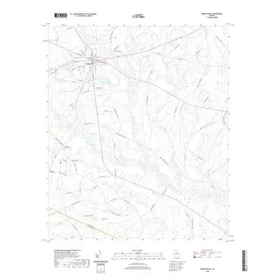
2020 Map of Wrightsville
USGS Topo · Published 2020About this map
Wrightsville serves as the focal point of this Johnson County landscape, centered on the Johnson County Courthouse and a dense grid of residential streets like W Court St and E Elm St. The town's historical geography is marked by local landmarks including West View View Cem and the Wrightsville Sewage Disposal Pond. Beyond the town limits, the topography is defined by the winding course of the Ohoopee River and several tributary systems such as Big Cedar Cr and Little Cedar Cr. This southern Georgia landscape transitions from the developed center of the county seat to rural outposts like Spann, characterized by small water bodies such as Lord Pond and Shurling Lake. Local genealogical sites are scattered across the quadrangle, including the rural Brantley Chapel Cem and Snell Cem, which provide specific points of interest for researchers tracing families in this part of the coastal plain.
Find a feature on this map
97 named features on this map. Tap any name to fly to it.
Don’t see what you’re looking for? This feature index may not catch every label — zoom into the map to look around manually.
Map Details
Editions of this 2020 Wrightsville Map
This is the sole edition of this map. No revisions or reprints were ever made.
Other maps of this area

1957 · Macon
USGS Topo · 1:250,000

1958 · Macon
USGS Topo · 1:250,000

1962 · Irwins Crossroads
USGS Topo · 1:24,000

1964 · Macon
USGS Topo · 1:250,000
1973 · Davisboro SE
USGS Topo · 1:24,000
1973 · Harrison
USGS Topo · 1:24,000

1974 · Kite
USGS Topo · 1:24,000

1974 · Wrightsville
USGS Topo · 1:24,000

1974 · East Dublin
USGS Topo · 1:24,000

1974 · Lovett
USGS Topo · 1:24,000