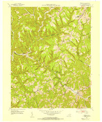
1953 Map of Wrigley
USGS Topo · Published 1954About this map
Cumberland National Forest blankets much of the high ground in this 1953 survey of Morgan and Rowan counties, where the Licking River winds through narrow valleys. The map shows a landscape defined by sharp ridges and isolated hollows, with small settlements like Wrigley and Blairs Mills serving as local hubs. The abundance of one-room schools, including Oak Grove Sch and Perkins Sch, suggests a community structure organized around these remote valley corridors.
Find a feature on this map
62 named features on this map. Tap any name to fly to it.
Don’t see what you’re looking for? This feature index may not catch every label — zoom into the map to look around manually.
Map Details
Editions of this 1953 Wrigley Map
2 editions found
Other maps of this area

1889 · Salyersville
USGS Topo · 1:125,000

1891 · Salyersville
USGS Topo · 1:125,000

1899 · Salyersville
USGS Topo · 1:125,000

1929 · Morehead
USGS Topo · 1:48,000

1935 · Morehead
USGS Topo · 1:62,500

1950 · Ault
USGS Topo · 1:24,000

1950 · Sandy Hook
USGS Topo · 1:24,000

1950 · Lenox
USGS Topo · 1:24,000

1951 · Ezel
USGS Topo · 1:24,000
1951 · Lenox
USGS Topo · 1:24,000