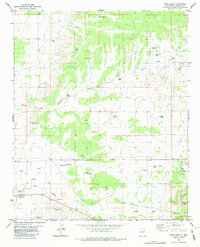
1982 Map of Wrye Peak
USGS Topo · Published 1982About this map
Wrye Ranch and Hinkle Ranch anchor this high-desert landscape in Socorro County, where ranching life relied on a complex network of wells and tanks during the early 1980s. The terrain is defined by the elevation of Wrye Peak and the passage through Cedar Pass, with drainage systems like Yellow Dog Canyon and Hoot Owl Canyon carving through the dry earth. These canyons, alongside Hale Wash, emphasize the importance of water management in this arid environment, evidenced by numerous features such as Bingham Well, South Corn Well, and Adobe Well.
Find a feature on this map
44 named features on this map. Tap any name to fly to it.
Don’t see what you’re looking for? This feature index may not catch every label — zoom into the map to look around manually.
Map Details
Editions of this 1982 Wrye Peak Map
2 editions found
Other maps of this area

1918 · Oscura Peak
USGS Topo · 1:125,000

1948 · Broken Back Crater
USGS Topo · 1:62,500

1948 · Bingham
USGS Topo · 1:62,500

1954 · Tularosa
USGS Topo · 1:250,000

1954 · Socorro
USGS Topo · 1:250,000

1958 · Socorro
USGS Topo · 1:250,000

1958 · Tularosa
USGS Topo · 1:250,000

1962 · Socorro
USGS Topo · 1:250,000

1972 · Turkey Ridge SW
USGS Topo · 1:24,000

1972 · Wilson Ranch
USGS Topo · 1:24,000