
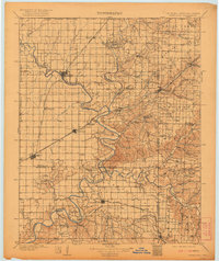
1909 Map of Wyandotte
USGS Topo · Published 1909About this map
The Neosho River and Spring River converge in this northeastern corner of Oklahoma, documenting the complex borderlands of the Cherokee and Quapaw nations during the early years of statehood. The terrain is characterized by broad prairies like Buffalo Prairie and Sweetwater Prairie, broken by the deep meanders of river bends such as Mudeater Bend and Echo Bend. A network of river crossings, including Rodwhite Ferry and Good Eagle Ferry, reveals a landscape where water travel remained vital even as the St. Louis and San Francisco RR expanded through Miami and Wyandotte.
Find a feature on this map
105 named features on this map. Tap any name to fly to it.
Don’t see what you’re looking for? This feature index may not catch every label — zoom into the map to look around manually.
Map Details
Editions of this 1909 Wyandotte Map
2 editions found
Other maps of this area

1886 · Joplin
USGS Topo · 1:125,000

1886 · Carthage
USGS Topo · 1:125,000

1886 · Parsons
USGS Topo · 1:125,000

1893 · Parsons
USGS Topo · 1:125,000

1894 · Joplin
USGS Topo · 1:125,000

1894 · Carthage
USGS Topo · 1:125,000

1896 · Pryor
USGS Topo · 1:125,000

1899 · Fayetteville
USGS Topo · 1:125,000

1899 · Siloam Springs
USGS Topo · 1:125,000

1901 · Vinita
USGS Topo · 1:125,000