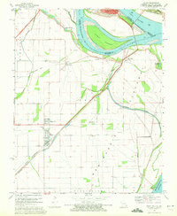
1969 Map of Wyatt
USGS Topo · Published 1972About this map
The confluence of the Mississippi River and the Ohio River dominates this landscape where Missouri, Illinois, and Kentucky meet. The map documents a critical hydrologic and transit corridor defined by an extensive Levee system protecting low-lying agricultural lands like Tywappity. Small community centers such as Wyatt and Wilson City are situated inland, while Birds Point sits at the strategic bend of the river. The rail infrastructure of the era is prominent, featuring lines like the St Louis Southwestern and the Illinois Central, alongside traces of an Old Railroad Grade.
Find a feature on this map
35 named features on this map. Tap any name to fly to it.
Don’t see what you’re looking for? This feature index may not catch every label — zoom into the map to look around manually.
Map Details
Editions of this 1969 Wyatt Map
2 editions found
Other maps of this area

1931 · Cairo
USGS Topo · 1:62,500

1933 · Cairo
USGS Topo · 1:62,500

1934 · Thebes
USGS Topo · 1:62,500

1939 · Wickliffe
USGS Topo · 1:62,500

1939 · Charleston
USGS Topo · 1:62,500

1939 · Cairo
USGS Topo · 1:62,500

1939 · Thebes
USGS Topo · 1:62,500

1949 · Paducah
USGS Topo · 1:250,000

1950 · Paducah
USGS Topo · 1:250,000

1951 · Wickliffe SW
USGS Topo · 1:24,000