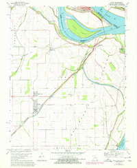
1969 Map of Wyatt
USGS Topo · Published 1978About this map
The confluence of the Ohio River and Mississippi River creates a dynamic landscape where Fort Defiance State Park sits at the very tip of the Illinois-Missouri-Kentucky border. This 1969 topographic study captures a complex system of levees and river-born terrain, including the prominent Angelo Towhead and several deep water pockets such as Deans Blue Hole and Tom Bird Blue Hole. The Missouri side is marked by the agricultural settlements of Wyatt, Wilson City, and Alfalfa Center, illustrating the region's reliance on fertile bottomlands protected by extensive embankments.
Find a feature on this map
37 named features on this map. Tap any name to fly to it.
Don’t see what you’re looking for? This feature index may not catch every label — zoom into the map to look around manually.
Map Details
Editions of this 1969 Wyatt Map
2 editions found
Other maps of this area

1931 · Cairo
USGS Topo · 1:62,500

1933 · Cairo
USGS Topo · 1:62,500

1934 · Thebes
USGS Topo · 1:62,500

1939 · Wickliffe
USGS Topo · 1:62,500

1939 · Charleston
USGS Topo · 1:62,500

1939 · Cairo
USGS Topo · 1:62,500

1939 · Thebes
USGS Topo · 1:62,500

1949 · Paducah
USGS Topo · 1:250,000

1950 · Paducah
USGS Topo · 1:250,000

1951 · Wickliffe SW
USGS Topo · 1:24,000