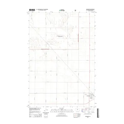
2014 Map of Wyndmere
USGS Topo · Published 2014About this map
Wyndmere sits at the intersection of Nd-13 and Nd-18 in this southern Richland County landscape. The town's grid is detailed with residential streets like Gilead Ave and commercial-industrial markers such as Elevator Rd, which hints at the area's agricultural foundations. Northwest of the settlement, the Sheyenne National Grassland dominates the terrain with a network of section-line roads including 153rd Ave SE and 73rd St SE. This protected area is characterized by numerous small depressions and wetlands common to the regional topography. Elk Creek meanders through the southern portion of the map, providing drainage for the surrounding prairie. The layout of the roads, such as Co Road 17, illustrates the strict township and range surveying system that organized the North Dakota plains into a regular grid of farms and ranches.
Find a feature on this map
30 named features on this map. Tap any name to fly to it.
Don’t see what you’re looking for? This feature index may not catch every label — zoom into the map to look around manually.
Map Details
Editions of this 2014 Wyndmere Map
This is the sole edition of this map. No revisions or reprints were ever made.
Other maps of this area

1907 · Wyndmere
USGS Topo · 1:125,000

1953 · Fargo
USGS Topo · 1:250,000

1956 · Fargo
USGS Topo · 1:250,000

1958 · Hamlin
USGS Topo · 1:24,000

1959 · Wyndmere NE
USGS Topo · 1:24,000

1960 · Wyndmere
USGS Topo · 1:24,000

1960 · Wyndmere NW
USGS Topo · 1:24,000

1960 · Wyndmere SE
USGS Topo · 1:24,000

1960 · De Lamere
USGS Topo · 1:24,000
1961 · McLeod
USGS Topo · 1:24,000