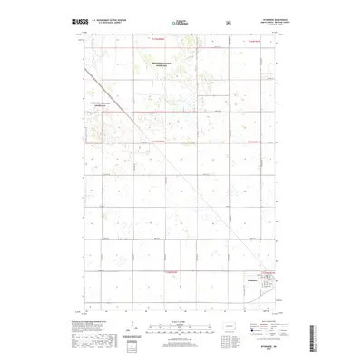
2020 Map of Wyndmere
USGS Topo · Published 2020About this map
Wyndmere sits at the intersection of a vast agricultural grid and the eastern reaches of the Sheyenne National Grassland in Richland County. This modern survey reflects the enduring structure of the Red River Valley’s prairie landscape, where the township and range system dictates a precise network of roads such as 79th St SE and 151st Ave SE. The town's local streets, including Birch Ave, Cedar Ave, and Gilead Ave, represent the concentrated residential core of an otherwise expansive rural territory. The southern portion of the map is marked by the winding path of Elk Cr, which provides a natural break in the otherwise strictly geometric section lines. The map documents the persistent layout of these prairie communities, where the transition from managed grassland to systematic cultivation remains a defining characteristic of the North Dakota interior.
Find a feature on this map
24 named features on this map. Tap any name to fly to it.
Don’t see what you’re looking for? This feature index may not catch every label — zoom into the map to look around manually.
Map Details
Editions of this 2020 Wyndmere Map
This is the sole edition of this map. No revisions or reprints were ever made.
Other maps of this area

1907 · Wyndmere
USGS Topo · 1:125,000

1953 · Fargo
USGS Topo · 1:250,000

1956 · Fargo
USGS Topo · 1:250,000

1958 · Hamlin
USGS Topo · 1:24,000

1959 · Wyndmere NE
USGS Topo · 1:24,000

1960 · Wyndmere
USGS Topo · 1:24,000

1960 · Wyndmere NW
USGS Topo · 1:24,000

1960 · Wyndmere SE
USGS Topo · 1:24,000

1960 · De Lamere
USGS Topo · 1:24,000
1961 · McLeod
USGS Topo · 1:24,000