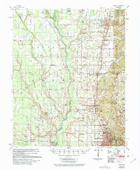
1958 Map of Wynne
USGS Topo · Published 1975About this map
Wynne and Forrest City anchor this mid-century survey of eastern Arkansas, where the L'Anguille River meanders through the heart of Cross County and St Francis County. The landscape is defined by its agrarian and industrial foundations, visible in the milling operations at Wick Mill and Slonikers Mill and the steady traffic along the Missouri Pacific and St Louis Southwestern railroads. These transit corridors fostered several small communities and rail stops such as Hamlin, Colt, and Caldwell.
Find a feature on this map
62 named features on this map. Tap any name to fly to it.
Don’t see what you’re looking for? This feature index may not catch every label — zoom into the map to look around manually.
Map Details
Editions of this 1958 Wynne Map
2 editions found

Other maps of this area

1939 · Vanndale
USGS Topo · 1:62,500

1939 · Park Place
USGS Topo · 1:62,500

1939 · Wynne
USGS Topo · 1:62,500

1939 · Hunter
USGS Topo · 1:62,500

1940 · Princedale
USGS Topo · 1:62,500

1940 · Whitmore
USGS Topo · 1:62,500

1940 · Brinkley
USGS Topo · 1:62,500

1940 · Marianna
USGS Topo · 1:62,500

1940 · Tilton
USGS Topo · 1:62,500

1948 · Helena
USGS Topo · 1:250,000