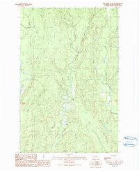
1990 Map of Wynoochee Valley NE
USGS Topo · Published 1990About this map
The West Fork Satsop River and Middle Fork Satsop River dominate this Olympic Peninsula landscape, showing the complex drainage patterns of the region's river valleys as they appeared in 1990. The survey, produced from photography taken in 1987, reveals a terrain defined by narrow ridges and numerous tributary streams like Neil Creek and Canyon Creek. To the west, the Wynoochee River carves its path through the timberlands, where the prominent height of Simpson stands as a local landmark.
Find a feature on this map
15 named features on this map. Tap any name to fly to it.
Don’t see what you’re looking for? This feature index may not catch every label — zoom into the map to look around manually.
Map Details
Editions of this 1990 Wynoochee Valley NE Map
This is the sole edition of this map. No revisions or reprints were ever made.
Other maps of this area

1921 · Satsop
USGS Topo · 1:62,500

1941 · Mobray
USGS Topo · 1:62,500

1943 · Nahwatzel Lake
USGS Topo · 1:62,500

1943 · Mobray
USGS Topo · 1:62,500

1953 · Mt Tebo
USGS Topo · 1:62,500

1953 · Elma
USGS Topo · 1:62,500

1955 · Wynoochee Valley
USGS Topo · 1:62,500

1955 · Grisdale
USGS Topo · 1:62,500

1958 · Seattle
USGS Topo · 1:250,000

1962 · Seattle
USGS Topo · 1:250,000