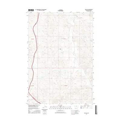
2017 Map of Wyola NE
USGS Topo · Published 2017About this map
The Little Bighorn River defines the western edge of this landscape, its course shadowed by the Fortymile Canal as it winds through the valley floor. This 2017 survey reveals an arid territory carefully managed for water, evidenced by a network of catchments including Brown Reservoir, Liming Reservoir, and Halfway Reservoir. These man-made features are vital anchors in a terrain dominated by drainage systems like Little Owl Cr and Lone Pine Cr. The prominent Chalk Butte and its adjacent Chalk Butte Reservoir serve as central landmarks within the Public Land Survey System grids of T7S and T8S. Local transit is limited to rural routes such as Little Owl Crk Rd and Big Owl Rd, which provide access to the high ground between the various creek branches. The map provides a contemporary record of land use and water rights in this portion of Big Horn County.
Find a feature on this map
22 named features on this map. Tap any name to fly to it.
Don’t see what you’re looking for? This feature index may not catch every label — zoom into the map to look around manually.
Map Details
Editions of this 2017 Wyola NE Map
This is the sole edition of this map. No revisions or reprints were ever made.
Other maps of this area

1894 · Rosebud
USGS Topo · 1:125,000

1901 · Rosebud
USGS Topo · 1:125,000

1954 · Hardin
USGS Topo · 1:250,000

1957 · Hardin
USGS Topo · 1:250,000

1958 · Hardin
USGS Topo · 1:250,000

1967 · Kid Creek
USGS Topo · 1:24,000

1967 · Wolf Mountain Lookout
USGS Topo · 1:24,000
1967 · Wyola
USGS Topo · 1:24,000
1967 · Wyola NE
USGS Topo · 1:24,000
1967 · Lodge Grass
USGS Topo · 1:24,000