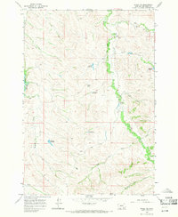
1967 Map of Wyola NE
USGS Topo · Published 1971About this map
The Crow Indian Reservation landscape in south-central Montana is defined by a network of seasonal drainages and early ranching infrastructure. The Little Bighorn R cuts through the western edge of the area, while the eastern terrain is marked by the winding courses of Owl Creek and its tributaries, Little Owl Creek and Dry Beaver Creek. This late 1960s survey illustrates how water management shaped the local economy, featuring numerous named catchments such as Liming Reservoir, Steinhilber Reservoir, and Chalk Butte Reservoir.
Find a feature on this map
21 named features on this map. Tap any name to fly to it.
Don’t see what you’re looking for? This feature index may not catch every label — zoom into the map to look around manually.
Map Details
Editions of this 1967 Wyola NE Map
This is the sole edition of this map. No revisions or reprints were ever made.
Other maps of this area

1894 · Rosebud
USGS Topo · 1:125,000

1901 · Rosebud
USGS Topo · 1:125,000

1954 · Hardin
USGS Topo · 1:250,000

1957 · Hardin
USGS Topo · 1:250,000

1958 · Hardin
USGS Topo · 1:250,000

1967 · Kid Creek
USGS Topo · 1:24,000

1967 · Wolf Mountain Lookout
USGS Topo · 1:24,000
1967 · Wyola
USGS Topo · 1:24,000
1967 · Lodge Grass
USGS Topo · 1:24,000
1967 · Good Luck Creek
USGS Topo · 1:24,000