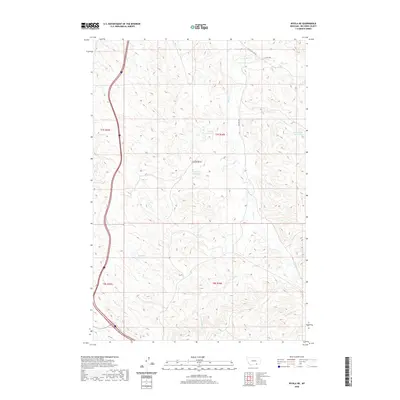
2020 Map of Wyola NE
USGS Topo · Published 2020About this map
Chalk Butte stands as a prominent landmark in this section of Big Horn County, overlooking a landscape defined by ranching water infrastructure and intermittent stream beds. This 2020 survey illustrates a sophisticated network of water management, ranging from the Fortymile Canal in the northwest to numerous upland catchments such as Steinhilber Reservoir and Liming Reservoir. The drainage patterns of Owl Cr, Little Owl Cr, and Halfway Cr dictate the local topography, while gravel routes like Little Owl Crk Rd and Big Owl Rd provide the primary access through these grazing lands. The map detail reflects the modern spatial organization of the area, maintaining the historic Public Land Survey System divisions while highlighting the vital role of water storage in this semi-arid environment through features like Chalk Butte Reservoir and Halfway Reservoir.
Find a feature on this map
21 named features on this map. Tap any name to fly to it.
Don’t see what you’re looking for? This feature index may not catch every label — zoom into the map to look around manually.
Map Details
Editions of this 2020 Wyola NE Map
This is the sole edition of this map. No revisions or reprints were ever made.
Other maps of this area

1894 · Rosebud
USGS Topo · 1:125,000

1901 · Rosebud
USGS Topo · 1:125,000

1954 · Hardin
USGS Topo · 1:250,000

1957 · Hardin
USGS Topo · 1:250,000

1958 · Hardin
USGS Topo · 1:250,000

1967 · Kid Creek
USGS Topo · 1:24,000

1967 · Wolf Mountain Lookout
USGS Topo · 1:24,000
1967 · Wyola
USGS Topo · 1:24,000
1967 · Wyola NE
USGS Topo · 1:24,000
1967 · Lodge Grass
USGS Topo · 1:24,000