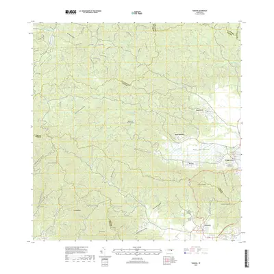
2018 Map of Yabucoa
USGS Topo · Published 2018About this map
The Valle de Yabucoa dominates this landscape, where the Río Guayanés and Río Limones converge near the coastal settlements. To the south and west, the terrain rises sharply into the Sierra de Cayey and the Cuchilla de Panduras, peaks that separate the municipality of Yabucoa from neighboring Maunabo. The survey documents the transition from the alluvial valley floor, home to established communities like Martorell and Rosa Sánchez, to the high ridges of the interior. Genealogists and local historians will find the exact locations of the Cementerio Municipal de Yabucoa and Cementerio Municipal Maunabo clearly marked. The drainage network is particularly dense here, with dozens of named streams including Quebrada Guayabo and Quebrada Alejandro carving through the mountain slopes.
Find a feature on this map
51 named features on this map. Tap any name to fly to it.
Don’t see what you’re looking for? This feature index may not catch every label — zoom into the map to look around manually.
Map Details
Editions of this 2018 Yabucoa Map
This is the sole edition of this map. No revisions or reprints were ever made.
Other maps of this area

1945 · Punta Tuna
USGS Topo · 1:30,000

1946 · Patillas
USGS Topo · 1:30,000

1946 · Humacao
USGS Topo · 1:30,000

1946 · Punta Guayanes
USGS Topo · 1:30,000

1946 · Juncos
USGS Topo · 1:30,000

1946 · Yabucoa
USGS Topo · 1:30,000

1946 · Guayama
USGS Topo · 1:30,000

1946 · Caguas
USGS Topo · 1:30,000
1947 · Humacao SO
USGS Topo · 1:10,000

1947 · Yabucoa SO
USGS Topo · 1:10,000