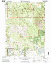
1998 Map of Yainax Butte
USGS Topo · Published 2000About this map
Winema National Forest and Fremont National Forest converge in this high-elevation corner of Klamath County, where the prominent Yainax Butte towers over a landscape defined by volcanic landforms and seasonal water management. This late-1990s landscape is dotted with small-scale water infrastructure like Bechholdt Reservoir, May Reservoir, and Mallory Reservoir, which support local ranching operations such as the Keno Springs Ranch. The terrain shifts from the open expanses of Sunset Prairie and Round Prairie to the steep relief of Rock Canyon, revealing a complex network of springs, including Whisky Creek and Tamarack Spring, that are vital to this arid forest environment. A notable Lookout Tower on the butte indicates the area's importance for regional fire observation, while scattered industrial sites like a Quarry and Gravel Pit highlight the local extraction of materials for forest road maintenance.
Find a feature on this map
41 named features on this map. Tap any name to fly to it.
Don’t see what you’re looking for? This feature index may not catch every label — zoom into the map to look around manually.
Map Details
Editions of this 1998 Yainax Butte Map
This is the sole edition of this map. No revisions or reprints were ever made.
Other maps of this area

1889 · Klamath
USGS Topo · 1:250,000

1894 · Klamath
USGS Topo · 1:250,000

1955 · Klamath Falls
USGS Topo · 1:250,000

1957 · Malin
USGS Topo · 1:62,500

1958 · Klamath Falls
USGS Topo · 1:250,000

1960 · Gerber Reservoir
USGS Topo · 1:62,500

1960 · Bly
USGS Topo · 1:62,500

1960 · Beatty
USGS Topo · 1:62,500
1988 · Yainax Butte
USGS Topo · 1:24,000
1988 · Bonanza
USGS Topo · 1:24,000