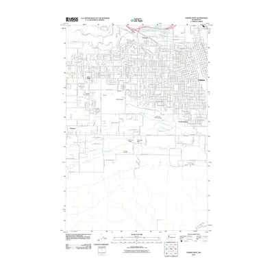
2011 Map of Yakima West
USGS Topo · Published 2011About this map
Yakima and its western suburbs are defined by a complex network of irrigation and aviation infrastructure in the early 21st century. The landscape transitions from the urban core of South Broadway and the Exchange district into the residential developments of West Valley and Ahtanum Valley. Critical water management features like the Union Canal, Congdon Canal, and the East Unit 1 Highline Canal are vital to this arid valley, supporting the surrounding agricultural economy. Aviation is a prominent theme on this map, with the large Yakima Air Terminal Airport occupying the central flats and the smaller Apple Valley Airport situated further south. For genealogists, the map identifies several significant burial sites, including the large Tahoma Cemetery and Calvary Cemetery, as well as the more localized Yemowat Cemetery near Ahtanum Creek. The northern boundary is marked by the Naches River and the rugged contours of Pecks Canyon.
Find a feature on this map
67 named features on this map. Tap any name to fly to it.
Don’t see what you’re looking for? This feature index may not catch every label — zoom into the map to look around manually.
Map Details
Editions of this 2011 Yakima West Map
This is the sole edition of this map. No revisions or reprints were ever made.
Other maps of this area

1899 · Ellensburg
USGS Topo · 1:125,000

1901 · Ellensburg
USGS Topo · 1:125,000

1910 · Zillah
USGS Topo · 1:125,000

1936 · Yakima East
USGS Topo · 1:48,000

1937 · White Swan
USGS Topo · 1:125,000

1941 · Yakima East
USGS Topo · 1:62,500

1950 · Yakima
USGS Topo · 1:250,000

1953 · Pomona
USGS Topo · 1:24,000

1953 · Yakima East
USGS Topo · 1:24,000
1953 · Yakima East
USGS Topo · 1:62,500