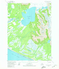
1959 Map of Yakutat B-3
USGS Topo · Published 1974About this map
The Brabazon Range dominates this coastal Alaskan landscape, where glacial runoff feeds an intricate network of braided rivers and marshlands. Large ice bodies like the Yakutat Glacier and Chamberlain Glacier drain into deep basins, most notably Harlequin Lake. The transition from alpine ice to the Gulf of Alaska is marked by a vast expanse of the Tongass National Forest, characterized by shifting river channels and seasonal wetlands. Human presence is sparse, represented by a lone Cabin and a remote Landing Strip near the banks of the Dangerous River. Of particular interest to those studying historical transport and access is the Akwe Tractor Trail, which runs parallel to the coastline between the Italio River and the Akwe River, providing a rare terrestrial link through the damp coastal plain.
Find a feature on this map
19 named features on this map. Tap any name to fly to it.
Don’t see what you’re looking for? This feature index may not catch every label — zoom into the map to look around manually.
Map Details
Editions of this 1959 Yakutat B-3 Map
2 editions found
Other maps of this area

1951 · Yakutat
USGS Topo · 1:250,000

1959 · Yakutat C-3
USGS Topo · 1:63,360

1959 · Yakutat A-2
USGS Topo · 1:63,360
1959 · Yakutat A-3
USGS Topo · 1:63,360

1959 · Yakutat C-4
USGS Topo · 1:63,360

1959 · Yakutat B-3
USGS Topo · 1:63,360

1959 · Yakutat B-2
USGS Topo · 1:63,360

1959 · Yakutat B-4
USGS Topo · 1:63,360

1959 · Yakutat
USGS Topo · 1:250,000

1985 · Yakutat C-2
USGS Topo · 1:63,360