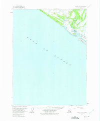
1959 Map of Yakutat B-5
USGS Topo · Published 1975About this map
Chief Situk Grave and a nearby Cem anchor the cultural landscape along the lower Situk River, marking a place of long-standing significance within the Tongass National Forest. This mid-century coastal survey documents the transition from the Gulf of Alaska to the intricate network of tidal waterways and silting estuaries. The economy of the era is evident at the Cannery situated near Johnson Slough and the cluster of Cabins positioned on the Ahrnklin River. Aviation infrastructure is established inland at the Yakutat Airport, which is connected to the shore by light-duty roads and radio communication sites. The coastal geography is defined by shifting sands and low-lying terrain, including Blacksand Island and the Blacksand Spit, where the rivers meet the sea.
Find a feature on this map
21 named features on this map. Tap any name to fly to it.
Don’t see what you’re looking for? This feature index may not catch every label — zoom into the map to look around manually.
Map Details
Editions of this 1959 Yakutat B-5 Map
2 editions found
Other maps of this area

1951 · Yakutat
USGS Topo · 1:250,000

1959 · Yakutat B-5
USGS Topo · 1:63,360

1959 · Yakutat C-5
USGS Topo · 1:63,360

1959 · Yakutat C-4
USGS Topo · 1:63,360

1959 · Yakutat B-4
USGS Topo · 1:63,360

1959 · Yakutat
USGS Topo · 1:250,000
1985 · Yakutat C-6
USGS Topo · 1:63,360

1987 · Yakutat C-4 SW
USGS Topo · 1:25,000
1987 · Yakutat C-5 SE
USGS Topo · 1:25,000
1987 · Yakutat B-5 NE
USGS Topo · 1:25,000