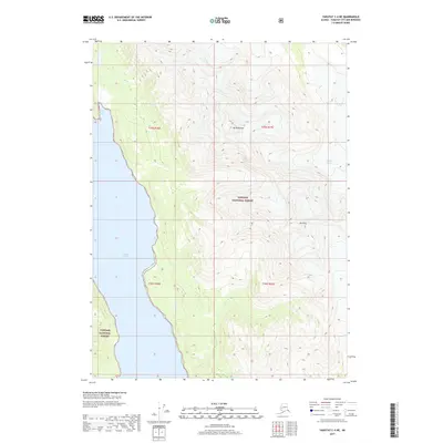
2017 Map of Yakutat C-4 NE
USGS Topo · Published 2017About this map
Tongass National Forest dominates this coastal Alaska landscape, where steep maritime topography meets the glacial waters of the Pacific Northwest. The terrain is defined by high peaks and shifting ice, with Mt Ruhamah and Mt Pinta rising sharply from the eastern interior. Along the shoreline, Russell Fiord carves deep into the mainland, providing a protected waterway north of Shelter Cove. The presence of the Hidden Glacier in the northeastern reaches of the quadrangle illustrates the active glaciology of the Yakutat region, showing the extent of ice flow and drainage patterns during this 2017 survey. This map offers a detailed view of a remote wilderness where federal forest lands and glacial inlets intersect, serving as an essential record for coastal geography and environmental change.
Find a feature on this map
10 named features on this map. Tap any name to fly to it.
Don’t see what you’re looking for? This feature index may not catch every label — zoom into the map to look around manually.
Map Details
Editions of this 2017 Yakutat C-4 NE Map
This is the sole edition of this map. No revisions or reprints were ever made.
Other maps of this area

1951 · Yakutat
USGS Topo · 1:250,000

1959 · Yakutat C-3
USGS Topo · 1:63,360

1959 · Yakutat D-3
USGS Topo · 1:63,360

1959 · Yakutat D-4
USGS Topo · 1:63,360

1959 · Yakutat C-4
USGS Topo · 1:63,360

1959 · Yakutat
USGS Topo · 1:250,000

1987 · Yakutat C-4 SW
USGS Topo · 1:25,000
1987 · Yakutat C-4 SE
USGS Topo · 1:25,000
1997 · Yakutat C-4
USGS Topo · 1:63,360
2017 · Yakutat D-4 SW
USGS Topo · 1:25,000