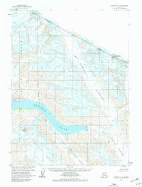
1959 Map of Yakutat D-3
USGS Topo · Published 1977About this map
Nunatak Fiord serves as the central drainage for an expansive icefield system where several massive ice flows converge. This 1959 field-annotated landscape is dominated by the West Nunatak Glacier and East Nunatak Glacier, which flank the prominent geological feature known as The Nunatak. The map documents the high-altitude boundary between British Columbia and Alaska, following a series of peaks including Mt Jette and Mt Aylesworth.
Find a feature on this map
18 named features on this map. Tap any name to fly to it.
Don’t see what you’re looking for? This feature index may not catch every label — zoom into the map to look around manually.
Map Details
Editions of this 1959 Yakutat D-3 Map
2 editions found
Other maps of this area

1951 · Yakutat
USGS Topo · 1:250,000

1951 · Mt Saint Elias
USGS Topo · 1:250,000

1959 · Yakutat C-3
USGS Topo · 1:63,360

1959 · Yakutat D-3
USGS Topo · 1:63,360

1959 · Yakutat D-4
USGS Topo · 1:63,360

1959 · Yakutat C-4
USGS Topo · 1:63,360

1959 · Yakutat
USGS Topo · 1:250,000

1959 · Mt Saint Elias
USGS Topo · 1:250,000
1985 · Mount Saint Elias A-4
USGS Topo · 1:63,360
1985 · Mount Saint Elias A-3
USGS Topo · 1:63,360