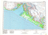
1959 Map of Yakutat
USGS Topo · Published 1982About this map
Yakutat serves as the focal point for this survey, situated on the edge of Monti Bay along the rugged northern Gulf coast. The landscape is dominated by the colossal Malaspina Glacier to the west and the intricate Yakutat Foreland to the east, a region defined by an extensive network of glacial meltwater streams including the Dangerous River and Situk River. The transportation infrastructure of the mid-20th century is highlighted by the Yakutat and Southern Railroad and the Yakutat Airport, reflecting the area's logistical importance between the mountains and the sea. The map traces the international boundary line between Alaska and British Columbia, cutting through the massive ice fields and high peaks like Mt Hendrickson and Mt Alexander. Natural features such as Russell Fiord and Disenchantment Bay illustrate the deep-water inlets that define this corner of the Tongass National Forest.
Find a feature on this map
78 named features on this map. Tap any name to fly to it.
Don’t see what you’re looking for? This feature index may not catch every label — zoom into the map to look around manually.
Map Details
Editions of this 1959 Yakutat Map
4 editions found

Other maps of this area

1950 · Bering Glacier
USGS Topo · 1:250,000

1950 · Icy Bay
USGS Topo · 1:250,000

1951 · Icy Bay
USGS Topo · 1:250,000

1951 · Bering Glacier
USGS Topo · 1:250,000

1951 · Yakutat
USGS Topo · 1:250,000

1951 · Mt Saint Elias
USGS Topo · 1:250,000

1951 · Mt Fairweather
USGS Topo · 1:250,000

1952 · Skagway
USGS Topo · 1:250,000

1959 · Yakutat A-1
USGS Topo · 1:63,360

1959 · Yakutat C-3
USGS Topo · 1:63,360