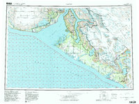
1959 Map of Yakutat
USGS Topo · Published 1982About this map
Malaspina Glacier dominates the western coastline of this Alaskan survey, its massive ice field meeting the Gulf of Alaska at the Sitkagi Bluffs. The settlement of Yakutat sits strategically on the Phipps Peninsula, sheltered from the open sea by Monti Bay and a complex network of islands including Knight Island. The landscape is a study in active glacial processes, where the Novatak Glacier and Alsek Glacier descend from the Saint Elias Mountains toward the Yakutat Foreland. Further south, the Alsek River and Dangerous River cut through the coastal lowlands, forming a dynamic delta system near Dry Bay. A notable Tractor Trail provides a rare inland connection between the Italio River and the Akwe Lake region, illustrating the difficult transit routes through the Tongass National Forest and Brabazon Range during this era.
Find a feature on this map
42 named features on this map. Tap any name to fly to it.
Don’t see what you’re looking for? This feature index may not catch every label — zoom into the map to look around manually.
Map Details
Editions of this 1959 Yakutat Map
4 editions found

Other maps of this area

1950 · Bering Glacier
USGS Topo · 1:250,000

1950 · Icy Bay
USGS Topo · 1:250,000

1951 · Icy Bay
USGS Topo · 1:250,000

1951 · Bering Glacier
USGS Topo · 1:250,000

1951 · Yakutat
USGS Topo · 1:250,000

1951 · Mt Saint Elias
USGS Topo · 1:250,000

1951 · Mt Fairweather
USGS Topo · 1:250,000

1952 · Skagway
USGS Topo · 1:250,000

1959 · Yakutat A-1
USGS Topo · 1:63,360

1959 · Yakutat C-3
USGS Topo · 1:63,360