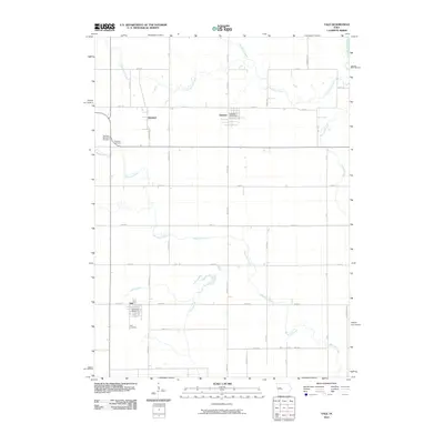
2010 Map of Yale
USGS Topo · Published 2010About this map
Yale and Jamaica anchor this portion of the Guthrie County landscape, where the rectilinear grid of rural roads meets a network of meandering waterways. The North Raccoon River cuts across the northeastern corner, while Mosquito Creek and Greenbrier Creek drain the surrounding prairie lands. These small settlements remain vital local hubs, marked by the presence of the Yale Post Office and Jamaica Post Office. The map captures a transition point at Herndon, situated at a significant road junction north of Yale. For those tracing local heritage, several burial grounds are preserved across the townships, including Richland Memorial Cemetery, Richland Cemetery, and Yale Cemetery. The geography is defined by a consistent pattern of agricultural section lines, interrupted only by the natural curves of Bay Branch and Fannys Branch.
Find a feature on this map
44 named features on this map. Tap any name to fly to it.
Don’t see what you’re looking for? This feature index may not catch every label — zoom into the map to look around manually.
Map Details
Editions of this 2010 Yale Map
This is the sole edition of this map. No revisions or reprints were ever made.
Other maps of this area

1949 · Adel
USGS Topo · 1:62,500

1950 · Perry
USGS Topo · 1:62,500

1951 · Perry
USGS Topo · 1:62,500

1951 · Adel
USGS Topo · 1:62,500

1952 · Panora
USGS Topo · 1:62,500

1954 · Bagley
USGS Topo · 1:62,500

1954 · Omaha
USGS Topo · 1:250,000

1957 · Omaha
USGS Topo · 1:250,000

1958 · Omaha
USGS Topo · 1:250,000
1982 · Rippey
USGS Topo · 1:24,000