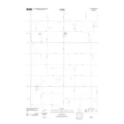
2013 Map of Yale
USGS Topo · Published 2013About this map
The town of Yale serves as a primary anchor in this Guthrie County landscape, where the local street grid including S St and Lincoln St meets the rural section lines. To the north, the small settlements of Jamaica and Herndon are connected by a network of agricultural roads and drainage patterns defined by Greenbrier Cr. The territory is etched by several small waterways, most notably the winding course of Mosquito Cr and the shorter reach of Bay Br, which drain the surrounding farmland. The arrangement of the town sites, particularly with Jamaica's street names like Railway St, suggests the legacy of the regional transit corridor that historically linked these prairie communities. This survey provides a clear view of the modern road system, from primary routes like 120th St to the numerous lettered and numbered avenues that partition the Iowa countryside.
Find a feature on this map
50 named features on this map. Tap any name to fly to it.
Don’t see what you’re looking for? This feature index may not catch every label — zoom into the map to look around manually.
Map Details
Editions of this 2013 Yale Map
This is the sole edition of this map. No revisions or reprints were ever made.
Other maps of this area

1949 · Adel
USGS Topo · 1:62,500

1950 · Perry
USGS Topo · 1:62,500

1951 · Perry
USGS Topo · 1:62,500

1951 · Adel
USGS Topo · 1:62,500

1952 · Panora
USGS Topo · 1:62,500

1954 · Bagley
USGS Topo · 1:62,500

1954 · Omaha
USGS Topo · 1:250,000

1957 · Omaha
USGS Topo · 1:250,000

1958 · Omaha
USGS Topo · 1:250,000
1982 · Rippey
USGS Topo · 1:24,000