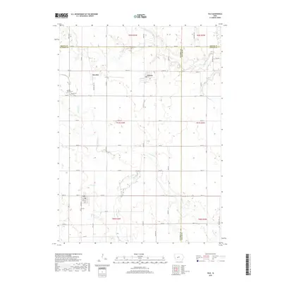
2018 Map of Yale
USGS Topo · Published 2018About this map
Yale, Jamaica, and Herndon anchor this corner of the Iowa plains where Guthrie, Greene, and Dallas Counties meet. The landscape is defined by the headwaters and drainages of Mosquito Cr and Greenbrier Cr, with smaller tributaries like Bay Br and Fannys Br cutting through the agricultural sections. This survey captures the rural infrastructure of the early 21st century, revealing a grid of section roads such as Victory Ave and Quest Ave that connect isolated farmsteads and cemeteries. Local heritage is preserved at sites like Richland Memorial Cem and Yale Cem. The mapping shows the continued significance of the historical township boundaries, including T82N R30W and T81N R29W, which have governed the layout of the land since the initial settlement.
Find a feature on this map
58 named features on this map. Tap any name to fly to it.
Don’t see what you’re looking for? This feature index may not catch every label — zoom into the map to look around manually.
Map Details
Editions of this 2018 Yale Map
This is the sole edition of this map. No revisions or reprints were ever made.
Other maps of this area

1949 · Adel
USGS Topo · 1:62,500

1950 · Perry
USGS Topo · 1:62,500

1951 · Perry
USGS Topo · 1:62,500

1951 · Adel
USGS Topo · 1:62,500

1952 · Panora
USGS Topo · 1:62,500

1954 · Bagley
USGS Topo · 1:62,500

1954 · Omaha
USGS Topo · 1:250,000

1957 · Omaha
USGS Topo · 1:250,000

1958 · Omaha
USGS Topo · 1:250,000
1982 · Rippey
USGS Topo · 1:24,000