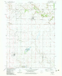
1982 Map of Yale
USGS Topo · Published 1983About this map
Yale serves as a primary hub in the southwest corner of this Guthrie County landscape, situated along the Chicago and North Western rail line. The rail corridor is a defining feature of the local economy, connecting Yale to the smaller settlements of Herndon and Jamaica to the north. This 1982 survey reveals an area defined by its water management and conservation efforts, including the Lakin Slough State Game Management Area and the Bay Branch State Game Management Area. The terrain is drained by a network of waterways including Mosquito Creek, Greenbrier Creek, and Fannys Branch, all eventually feeding toward the Raccoon River in the northeast. Genealogists will find the Richland Memorial Cemetery and Richland Cemetery preserved west of the rail junction near Herndon, marking the long-standing community roots in Richland township.
Find a feature on this map
21 named features on this map. Tap any name to fly to it.
Don’t see what you’re looking for? This feature index may not catch every label — zoom into the map to look around manually.
Map Details
Editions of this 1982 Yale Map
This is the sole edition of this map. No revisions or reprints were ever made.
Other maps of this area

1949 · Adel
USGS Topo · 1:62,500

1950 · Perry
USGS Topo · 1:62,500

1951 · Perry
USGS Topo · 1:62,500

1951 · Adel
USGS Topo · 1:62,500

1952 · Panora
USGS Topo · 1:62,500

1954 · Bagley
USGS Topo · 1:62,500

1954 · Omaha
USGS Topo · 1:250,000

1957 · Omaha
USGS Topo · 1:250,000

1958 · Omaha
USGS Topo · 1:250,000
1982 · Rippey
USGS Topo · 1:24,000