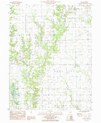
1985 Map of Yale
USGS Topo · Published 1985About this map
Sam Parr State Park anchors the southwestern corner of this Jasper County landscape, where the waters of Lake Jasper meet a complex drainage system defined by Crooked Creek and its many branches. The 1980s terrain is characterized by a mix of agricultural plots and active petroleum extraction, with numerous Oil Field designations scattered across the townships of Grandville, Hunt City, and Willow Hill. Small rural centers provide the primary points of settlement, most notably the village of Yale in the north and the crossroads at Hunt City. This period of the county's history reveals a balance between conservation and industry, as well as remnants of mid-century Americana like the Drive-In Theater located along the main thoroughfare. Genealogists will find the map useful for locating specific family homesteads and several small Cem sites tucked into the river bends and field edges.
Find a feature on this map
15 named features on this map. Tap any name to fly to it.
Don’t see what you’re looking for? This feature index may not catch every label — zoom into the map to look around manually.
Map Details
Editions of this 1985 Yale Map
This is the sole edition of this map. No revisions or reprints were ever made.
Other maps of this area

1910 · Hardinville
USGS Topo · 1:62,500

1940 · Greenup
USGS Topo · 1:62,500

1941 · Newton
USGS Topo · 1:62,500

1943 · Greenup
USGS Topo · 1:62,500

1943 · Newton
USGS Topo · 1:62,500

1953 · Indianapolis
USGS Topo · 1:250,000

1956 · Indianapolis
USGS Topo · 1:250,000

1956 · Annapolis
USGS Topo · 1:62,500

1956 · Vincennes
USGS Topo · 1:250,000

1957 · Indianapolis
USGS Topo · 1:250,000