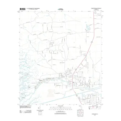
2012 Map of Yankeetown
USGS Topo · Published 2012About this map
The Withlacoochee River carves a path through the low-lying wetlands of Levy County, defining the spatial relationship between the neighboring settlements of Inglis and Yankeetown. This survey illustrates the intricate network of tidal creeks and marshes, including Demory Cr and Fuller Cr, as they flow toward the Gulf of Mexico. The human geography is marked by distinct residential clusters like Crackertown and specialized sites such as TFD Camp. A significant engineering feature, the Cross Florida Barge Canal, cuts a straight horizontal line across the lower landscape, contrasting with the meandering natural waterways. Local landmarks like Priest Cem and the Sulphur Spring provide specific points of interest for genealogists and local historians tracking the development of these riverfront communities. The presence of Gulf Hammock and Cedar Hammock indicates the wooded, coastal character of the terrain just inland from the gulf.
Find a feature on this map
173 named features on this map. Tap any name to fly to it.
Don’t see what you’re looking for? This feature index may not catch every label — zoom into the map to look around manually.
Map Details
Editions of this 2012 Yankeetown Map
This is the sole edition of this map. No revisions or reprints were ever made.
Other maps of this area

1954 · Crystal River
USGS Topo · 1:24,000

1954 · Red Level
USGS Topo · 1:24,000

1954 · Yankeetown SE
USGS Topo · 1:24,000

1954 · Gainesville
USGS Topo · 1:250,000

1955 · Lebanon Station
USGS Topo · 1:24,000

1955 · Withlacoochee Bay
USGS Topo · 1:24,000

1955 · Waccasassa Bay
USGS Topo · 1:24,000

1955 · Yankeetown
USGS Topo · 1:24,000

1955 · Tidewater
USGS Topo · 1:24,000

1955 · Plant City
USGS Topo · 1:250,000