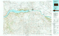
1985 Map of Yankton
USGS Topo · Published 1989About this map
Lewis and Clark Lake dominates the central landscape of this 1980s survey, formed by the Gavins Point Dam along the border of South Dakota and Nebraska. This man-made reservoir and the regulated flow of the Missouri River define the region's geography, south of the city of Yankton. The map reveals a complex borderlands culture where the Santee Indian Reservation in Nebraska faces the developing riverfront of South Dakota, including the Gavins Point National Fish Hatchery and the Chief White Crane Recreation Area. In the north, the Bon Homme Colony and the prominent Spirit Mound provide distinctive cultural and geological anchors. Settlement patterns reflect the influence of the Chicago Milwaukee St Paul and Pacific railroad, which historically connected agricultural hubs like Tyndall, Tabor, and Utica to the larger river economy.
Find a feature on this map
85 named features on this map. Tap any name to fly to it.
Don’t see what you’re looking for? This feature index may not catch every label — zoom into the map to look around manually.
Map Details
Editions of this 1985 Yankton Map
2 editions found
Other maps of this area

1897 · Canton
USGS Topo · 1:125,000

1898 · Olivet
USGS Topo · 1:125,000

1898 · Parker
USGS Topo · 1:125,000

1898 · Elk Point
USGS Topo · 1:125,000

1900 · Canton
USGS Topo · 1:125,000

1901 · Elk Point
USGS Topo · 1:125,000

1907 · Elk Point
USGS Topo · 1:125,000

1950 · Niobrara
USGS Topo · 1:24,000

1950 · Verdigre NE
USGS Topo · 1:24,000

1954 · Verdigre
USGS Topo · 1:24,000