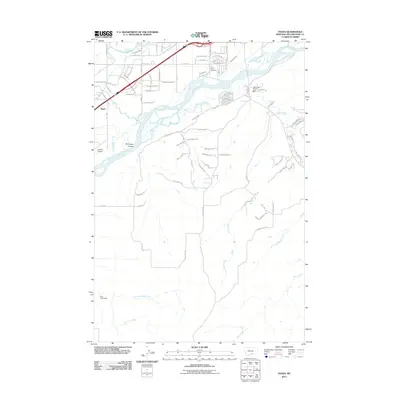
2011 Map of Yegen
USGS Topo · Published 2011About this map
The Yellowstone River anchors this landscape southwest of Billings, shaping the local irrigation and settlement patterns that define the region. In the early 21st century, the area shows a mix of suburban development and rural homesteading, evidenced by the Ross Homestead to the west and modern infrastructure like the Blue Creek Vol Fire Dept. The terrain is marked by significant water management features such as the Suburban Ditch and natural landforms like Brockway Coulee. Historical and community landmarks are scattered throughout, including the Holy Cross Cemetery and the settlement of Yegen. A network of creeks, including Canyon Creek, Basin Creek, and Newman Creek, suggests a well-watered valley floor transitioning into higher ground, while Airpark Oscars indicates the intersection of local aviation and residential growth.
Find a feature on this map
88 named features on this map. Tap any name to fly to it.
Don’t see what you’re looking for? This feature index may not catch every label — zoom into the map to look around manually.
Map Details
Editions of this 2011 Yegen Map
This is the sole edition of this map. No revisions or reprints were ever made.
Other maps of this area

1893 · Huntley
USGS Topo · 1:125,000

1954 · Billings
USGS Topo · 1:250,000

1956 · Rimrock
USGS Topo · 1:24,000

1956 · Yegen
USGS Topo · 1:24,000

1956 · Billings East
USGS Topo · 1:24,000

1956 · Mossmain
USGS Topo · 1:24,000

1957 · Billings
USGS Topo · 1:250,000

1957 · Billings West
USGS Topo · 1:24,000

1958 · Billings
USGS Topo · 1:250,000
1967 · Mossmain SW
USGS Topo · 1:24,000