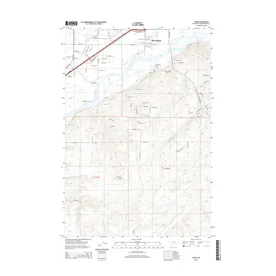
2014 Map of Yegen
USGS Topo · Published 2014About this map
Billings expands southward toward the Yellowstone River in this modern topographical study, revealing the complex intersection of urban development and Montana’s natural drainage patterns. The northern section is dominated by suburban growth and commercial corridors, including Zoo Dr and Overland Ave, while the Holy Cross Cem sits near the river's northern bank. South of the river, the landscape shifts abruptly into the high, contoured terrain of Brockway Coulee and Secret Valley, where the land is carved by numerous watercourses like E Fork Duck Cr and Little Basin Cr. This transition from the structured street grids of Yegen to the open, dissected uplands highlights the geographic constraints and irrigation history of the region, notably seen through the winding path of the Suburban Ditch.
Find a feature on this map
76 named features on this map. Tap any name to fly to it.
Don’t see what you’re looking for? This feature index may not catch every label — zoom into the map to look around manually.
Map Details
Editions of this 2014 Yegen Map
This is the sole edition of this map. No revisions or reprints were ever made.
Other maps of this area

1893 · Huntley
USGS Topo · 1:125,000

1954 · Billings
USGS Topo · 1:250,000

1956 · Rimrock
USGS Topo · 1:24,000

1956 · Yegen
USGS Topo · 1:24,000

1956 · Billings East
USGS Topo · 1:24,000

1956 · Mossmain
USGS Topo · 1:24,000

1957 · Billings
USGS Topo · 1:250,000

1957 · Billings West
USGS Topo · 1:24,000

1958 · Billings
USGS Topo · 1:250,000
1967 · Mossmain SW
USGS Topo · 1:24,000