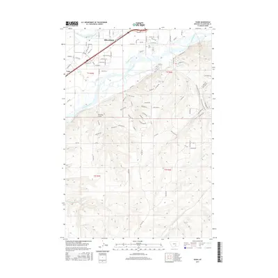
2017 Map of Yegen
USGS Topo · Published 2017About this map
The Yellowstone River cuts a wide path through this portion of Yellowstone County, separating the expanding residential and industrial fringes of southwest Billings from the more dissected uplands to the south. This 2017 survey shows a landscape defined by water management and topography, where the Billings Bench Water Association Canal and the Suburban Ditch snake across the valley floor to support local agriculture. North of the river, the settlement of Yegen sits at a crossroads of early transit routes, while the Holy Cross Cem serves as a grounded landmark for local genealogy.
Find a feature on this map
95 named features on this map. Tap any name to fly to it.
Don’t see what you’re looking for? This feature index may not catch every label — zoom into the map to look around manually.
Map Details
Editions of this 2017 Yegen Map
This is the sole edition of this map. No revisions or reprints were ever made.
Other maps of this area

1893 · Huntley
USGS Topo · 1:125,000

1954 · Billings
USGS Topo · 1:250,000

1956 · Rimrock
USGS Topo · 1:24,000

1956 · Yegen
USGS Topo · 1:24,000

1956 · Billings East
USGS Topo · 1:24,000

1956 · Mossmain
USGS Topo · 1:24,000

1957 · Billings
USGS Topo · 1:250,000

1957 · Billings West
USGS Topo · 1:24,000

1958 · Billings
USGS Topo · 1:250,000
1967 · Mossmain SW
USGS Topo · 1:24,000