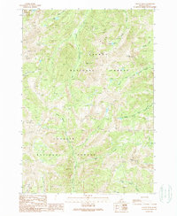
1989 Map of Yellow Peak
USGS Topo · Published 1989About this map
Blue Jay Mine and the Ray Lode Mine sit high in the Lemhi Range, marking a landscape defined by 20th-century resource extraction within the Salmon and Challis National Forests. This high-altitude drainage network feeds the complex systems of Big Timber Creek and Eightmile Creek, while secluded alpine basins harbor Devils Lake, Everson Lake, and Dairy Lake. The map reveals the boundary between the Salmon National Forest and Challis National Forest, highlighting the steep topographic transition from Gunsight Peak down to the creek-carved ravines of Devils Canyon. This record captures the area at a time when traditional pack trails and mine roads provided the primary access to the peaks, preserving the spatial relationship between isolated mineral claims and the massive watershed that defines this portion of Lemhi County.
Find a feature on this map
25 named features on this map. Tap any name to fly to it.
Don’t see what you’re looking for? This feature index may not catch every label — zoom into the map to look around manually.
Map Details
Editions of this 1989 Yellow Peak Map
This is the sole edition of this map. No revisions or reprints were ever made.
Other maps of this area

1935 · Borah Peak
USGS Topo · 1:125,000

1938 · Borah Peak
USGS Topo · 1:125,000

1955 · Dubois
USGS Topo · 1:250,000

1956 · Leadore
USGS Topo · 1:62,500

1956 · Patterson
USGS Topo · 1:62,500

1956 · Donkey Hills
USGS Topo · 1:62,500

1957 · Gilmore
USGS Topo · 1:62,500

1958 · Dubois
USGS Topo · 1:250,000

1980 · Leadore
USGS Topo · 1:100,000
1987 · West of Leadore
USGS Topo · 1:24,000