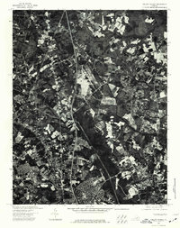
1974 Map of Yellow Tavern
USGS Topo · Published 1977About this map
The Chickahominy river basin dominates this 1974 orthophotoquad, which provides a high-altitude visual record of the landscape north of Richmond during a period of significant suburban expansion. Unlike traditional topographic maps that use symbols and contours, this imagery-based study captures the actual footprint of mid-1970s development, showing the precise carving of residential cul-de-sacs and commercial corridors into the surrounding forest and farmland. The dark, winding path of the Chickahominy provides a sharp contrast to the geometric patterns of the interstate highway and newer housing tracts. For researchers, the map serves as a primary source for observing the specific moment when rural Hanover County began its rapid transition into a modernized suburban corridor, preserving the exact layout of properties and tree lines that have since been altered by decades of further growth.
Find a feature on this map
1 named feature on this map. Tap any name to fly to it.
Don’t see what you’re looking for? This feature index may not catch every label — zoom into the map to look around manually.
Map Details
Editions of this 1974 Yellow Tavern Map
This is the sole edition of this map. No revisions or reprints were ever made.
Other maps of this area

1890 · Goochland
USGS Topo · 1:125,000

1892 · Goochland
USGS Topo · 1:125,000

1894 · Richmond
USGS Topo · 1:62,500

1895 · Richmond
USGS Topo · 1:62,500

1918 · Doswell
USGS Topo · 1:62,500

1934 · Seven Pines
USGS Topo · 1:24,000

1934 · Richmond
USGS Topo · 1:24,000

1936 · Richmond West
USGS Topo · 1:24,000

1936 · Glen Allen
USGS Topo · 1:24,000

1938 · Seven Pines
USGS Topo · 1:31,680