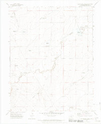
1970 Map of Yellowbank Creek
USGS Topo · Published 1974About this map
Arid grazing lands and water management infrastructure define this 1970 landscape in the high plains south of the Arkansas River. The territory is marked by a network of intermittent drainages like Yellowbank Creek and Mustang Creek, where ranching operations relied on an extensive system of man-made catchments and wells. Family-named landmarks such as the Altman Windmill, Weinegar Windmill, and Derringer Windmill indicate the vital role of groundwater extraction for livestock.
Find a feature on this map
26 named features on this map. Tap any name to fly to it.
Don’t see what you’re looking for? This feature index may not catch every label — zoom into the map to look around manually.
Map Details
Editions of this 1970 Yellowbank Creek Map
4 editions found
Other maps of this area

1891 · Nepesta
USGS Topo · 1:125,000

1891 · Apishapa
USGS Topo · 1:125,000

1893 · Nepesta
USGS Topo · 1:125,000

1893 · Apishapa
USGS Topo · 1:125,000

1897 · Apishapa
USGS Topo · 1:125,000

1904 · Nepesta
USGS Topo · 1:125,000

1954 · Trinidad
USGS Topo · 1:250,000

1954 · Pueblo
USGS Topo · 1:250,000

1955 · Trinidad
USGS Topo · 1:250,000

1957 · Pueblo
USGS Topo · 1:250,000