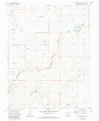
1970 Map of Yellowbank Creek
USGS Topo · Published 1985About this map
Yellowbank Creek and Mustang Creek carve through this Pueblo County landscape, defining a region where water management is the primary driver of settlement and land use. The map reveals an intricate network of livestock-related infrastructure, including numerous reservoirs such as Schoolhouse Reservoir, Baldwin Reservoir, and the evocatively named Bombing Range Reservoir. These water bodies are complemented by a series of family-named water sources, suggesting a history of ranching and land tenure marked by Weinegar Windmill, Derringer Windmill, and Altman Windmill.
Find a feature on this map
26 named features on this map. Tap any name to fly to it.
Don’t see what you’re looking for? This feature index may not catch every label — zoom into the map to look around manually.
Map Details
Editions of this 1970 Yellowbank Creek Map
4 editions found
Other maps of this area

1891 · Nepesta
USGS Topo · 1:125,000

1891 · Apishapa
USGS Topo · 1:125,000

1893 · Nepesta
USGS Topo · 1:125,000

1893 · Apishapa
USGS Topo · 1:125,000

1897 · Apishapa
USGS Topo · 1:125,000

1904 · Nepesta
USGS Topo · 1:125,000

1954 · Trinidad
USGS Topo · 1:250,000

1954 · Pueblo
USGS Topo · 1:250,000

1955 · Trinidad
USGS Topo · 1:250,000

1957 · Pueblo
USGS Topo · 1:250,000