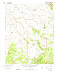
1955 Map of Yellowstone Canyon
USGS Topo · Published 1973About this map
Navajo Indian Reservation lands within Apache County are defined by a complex network of canyons and mesas captured during this mid-century survey. The southern portion of the map is dominated by the northern reaches of the Canyon De Chelly National Monument, where the geography transitions from the broad Yellowstone Canyon into the deep incisions of Canyon de Chelly and Muerto Canyon. Evidence of ancient habitation is marked at Cliff Dwelling Ruins near the confluence of Middle Trail Canyon and Pine Tree Canyon.
Find a feature on this map
52 named features on this map. Tap any name to fly to it.
Don’t see what you’re looking for? This feature index may not catch every label — zoom into the map to look around manually.
Map Details
Editions of this 1955 Yellowstone Canyon Map
2 editions found
Other maps of this area

1892 · Canyon De Chelly
USGS Topo · 1:250,000

1953 · Redrock Valley SW
USGS Topo · 1:24,000

1953 · Los Gigantes SE
USGS Topo · 1:24,000

1953 · Los Gigantes SW
USGS Topo · 1:24,000

1953 · Los Gigantes Buttes
USGS Topo · 1:62,500

1953 · Redrock Valley
USGS Topo · 1:62,500

1954 · Shiprock
USGS Topo · 1:250,000

1955 · Chinle 4 NE
USGS Topo · 1:24,000
1955 · Sonsala Butte 1 NW
USGS Topo · 1:24,000

1955 · Sonsala Butte 2 SW
USGS Topo · 1:24,000