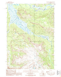
1989 Map of Yellowstone Point
USGS Topo · Published 1989About this map
Yellowstone River and Thorofare Creek converge in this high-altitude landscape within the Teton Wilderness, creating a complex network of wetlands and river bends near the northern boundary of the Teton National Forest. The presence of the Hawks Rest Patrol Cabin near the prominent landmark of Hawks Rest signifies the area's role in wilderness management and backcountry patrol during the late 20th century.
Find a feature on this map
20 named features on this map. Tap any name to fly to it.
Don’t see what you’re looking for? This feature index may not catch every label — zoom into the map to look around manually.
Map Details
Editions of this 1989 Yellowstone Point Map
This is the sole edition of this map. No revisions or reprints were ever made.
Other maps of this area

1885 · Lake
USGS Topo · 1:125,000

1893 · Ishawooa
USGS Topo · 1:125,000

1895 · Ishawooa
USGS Topo · 1:125,000

1895 · Lake
USGS Topo · 1:125,000

1896 · Lake
USGS Topo · 1:125,000

1899 · Ishawooa
USGS Topo · 1:125,000

1901 · Lake
USGS Topo · 1:125,000

1902 · Mt Leidy
USGS Topo · 1:125,000

1905 · Younts Peak
USGS Topo · 1:125,000

1906 · Lake
USGS Topo · 1:125,000