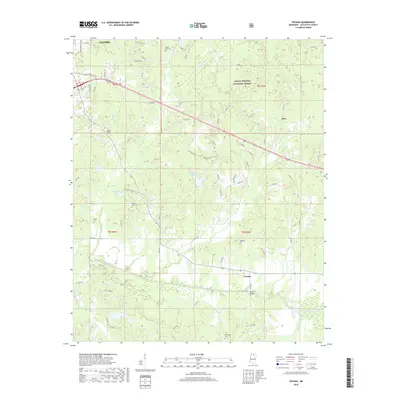
2018 Map of Yocona
USGS Topo · Published 2018About this map
The southern outskirts of Oxford give way to the wooded drainages and rolling hills of the Holly Springs National Forest in this survey of Lafayette County. The landscape is defined by the winding course of the Yocona River and its numerous tributaries, including Pumpkin Creek and Yellow Leaf Creek. Small communities like Yocona, Sand Hill, and Altus are linked by a network of county roads, with several family and community burial grounds, such as Kingdom Cemetery and Yellow Leaf Cemetery, offering vital touchpoints for local genealogical research. In the center of the map, Lafayette Lake and Stephens Lake break the forest cover, while Oliver Bridge provides a documented crossing over the river. The proximity to the growing university town is evident in the transition from suburban streets like University Avenue to the rural timberlands and creek bottoms that dominate the southern half of the sheet.
Find a feature on this map
84 named features on this map. Tap any name to fly to it.
Don’t see what you’re looking for? This feature index may not catch every label — zoom into the map to look around manually.
Map Details
Editions of this 2018 Yocona Map
This is the sole edition of this map. No revisions or reprints were ever made.
Other maps of this area

1940 · Oxford
USGS Topo · 1:62,500

1942 · Denmark
USGS Topo · 1:62,500

1943 · Denmark
USGS Topo · 1:62,500

1943 · Oxford
USGS Topo · 1:62,500

1954 · Water Valley
USGS Topo · 1:62,500

1955 · Water Valley
USGS Topo · 1:62,500

1956 · Tupelo
USGS Topo · 1:250,000

1958 · Tupelo
USGS Topo · 1:250,000

1972 · Paris
USGS Topo · 1:24,000
1972 · Tula
USGS Topo · 1:24,000