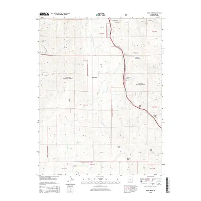
2014 Map of Yogo Creek
USGS Topo · Published 2014About this map
Fishlake National Forest encompasses the vast majority of this high-altitude landscape, where the headwaters of numerous mountain streams carve through the plateau. Significant waterways including Yogo Creek, Nioche Creek, and Meadow Creek define the drainage patterns, feeding into local landmarks like Mud Lake and a series of Beaver Dams at the southern edge. The terrain is marked by distinctive geological features such as Moroni Peak and the expansive Flat Top Mountain. This area is characterized by a network of forest access routes like Convulsion Road and Catamount Road, which provide entry into the various hollows and canyons. Features such as Corral Hole and Saddlehorse Canyon suggest a history of local livestock management within the protected forest boundaries, while names like Culvert Hollow and Aspen Hollow indicate specific ecological and infrastructural points of interest in this remote interior.
Find a feature on this map
36 named features on this map. Tap any name to fly to it.
Don’t see what you’re looking for? This feature index may not catch every label — zoom into the map to look around manually.
Map Details
Editions of this 2014 Yogo Creek Map
This is the sole edition of this map. No revisions or reprints were ever made.
Other maps of this area

1885 · Fish Lake
USGS Topo · 1:250,000

1896 · Fish Lake
USGS Topo · 1:250,000

1922 · Emery No.3
USGS Topo · 1:31,680

1925 · Acord Lakes
USGS Topo · 1:62,500

1956 · Salina
USGS Topo · 1:250,000

1960 · Salina
USGS Topo · 1:250,000

1962 · Salina
USGS Topo · 1:250,000
1966 · Steves Mtn
USGS Topo · 1:24,000
1966 · Water Hollow Ridge
USGS Topo · 1:24,000

1966 · Yogo Creek
USGS Topo · 1:24,000