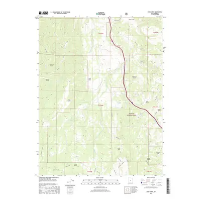
2017 Map of Yogo Creek
USGS Topo · Published 2017About this map
Fishlake National Forest encompasses the high-altitude terrain of Sevier County in this 2017 survey, where a complex network of canyons and peaks defines the drainage patterns. The map centers on the winding course of Yogo Creek and its convergence with Blackham Creek, surrounded by prominent landmarks like Flat Top Mountain and Moroni Peak. The landscape is etched with historical and modern thoroughfares, including the Great Western Trail (D-4) and the Sheep Valley - Moroni route. To the north, Convulsion Canyon Road skirts the edge of Spring Canyon near the Sevier and Emery county lines. Significant recreational and water management features are present, such as the Beaver Dams Loop and the marshy expanse of Mud Lake, providing a clear record of land use within the national forest system during the early 21st century.
Find a feature on this map
45 named features on this map. Tap any name to fly to it.
Don’t see what you’re looking for? This feature index may not catch every label — zoom into the map to look around manually.
Map Details
Editions of this 2017 Yogo Creek Map
This is the sole edition of this map. No revisions or reprints were ever made.
Other maps of this area

1885 · Fish Lake
USGS Topo · 1:250,000

1896 · Fish Lake
USGS Topo · 1:250,000

1922 · Emery No.3
USGS Topo · 1:31,680

1925 · Acord Lakes
USGS Topo · 1:62,500

1956 · Salina
USGS Topo · 1:250,000

1960 · Salina
USGS Topo · 1:250,000

1962 · Salina
USGS Topo · 1:250,000
1966 · Steves Mtn
USGS Topo · 1:24,000
1966 · Water Hollow Ridge
USGS Topo · 1:24,000

1966 · Yogo Creek
USGS Topo · 1:24,000