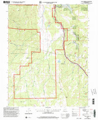
2001 Map of Yogo Creek
USGS Topo · Published 2003About this map
Fishlake National Forest dominates this high-altitude landscape, where the Meadow Gulch Administrative Site serves as a remote hub for forest management. The terrain is defined by dramatic elevation changes, from the heights of Flat Top Mountain and Maroni Peak down to the intricate drainage systems of Nioche Creek and Yogo Creek. Resource management and early infrastructure are evident through the presence of scattered Gravel Pits, a Drill Hole, and a Pit near Meadow Creek.
Find a feature on this map
42 named features on this map. Tap any name to fly to it.
Don’t see what you’re looking for? This feature index may not catch every label — zoom into the map to look around manually.
Map Details
Editions of this 2001 Yogo Creek Map
This is the sole edition of this map. No revisions or reprints were ever made.
Other maps of this area

1885 · Fish Lake
USGS Topo · 1:250,000

1896 · Fish Lake
USGS Topo · 1:250,000

1922 · Emery No.3
USGS Topo · 1:31,680

1925 · Acord Lakes
USGS Topo · 1:62,500

1956 · Salina
USGS Topo · 1:250,000

1960 · Salina
USGS Topo · 1:250,000

1962 · Salina
USGS Topo · 1:250,000
1966 · Steves Mtn
USGS Topo · 1:24,000
1966 · Water Hollow Ridge
USGS Topo · 1:24,000

1966 · Yogo Creek
USGS Topo · 1:24,000