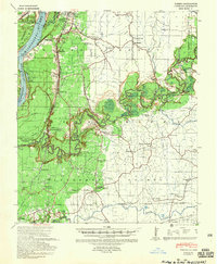
1939 Map of Yokena
USGS Topo · Published 1958About this map
The Mississippi River and its shifting backwaters define this stretch of the lower valley, where the 1933 engineering of the Diamond Cut-off altered the river's course near Oak Bend. Settlement follows the high ground and the corridor of the Yazoo and Mississippi Valley Railroad, which connects hamlets like Yokena and Warrenton to the regional hub at Vicksburg. The map reveals a landscape heavily shaped by local education and faith, evidenced by numerous country schoolhouses and churches such as Hardscrabble Sch and Campbell Chapel.
Find a feature on this map
66 named features on this map. Tap any name to fly to it.
Don’t see what you’re looking for? This feature index may not catch every label — zoom into the map to look around manually.
Map Details
Editions of this 1939 Yokena Map
2 editions found
Other maps of this area

1909 · Mound
USGS Topo · 1:24,000

1910 · Mound
USGS Topo · 1:31,680

1918 · Vicksburg
USGS Topo · 1:62,500

1938 · Edwards
USGS Topo · 1:62,500

1939 · Talla Bena
USGS Topo · 1:62,500

1939 · Yokena
USGS Topo · 1:62,500

1939 · Lorman
USGS Topo · 1:62,500

1941 · Vicksburg
USGS Topo · 1:62,500

1953 · Natchez
USGS Topo · 1:250,000

1955 · Jackson
USGS Topo · 1:250,000