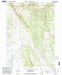
1998 Map of Yonna
USGS Topo · Published 2000About this map
Hildebrand and the settlement of Yonna sit at the western edge of a landscape defined by the transition from flat valley floors to the timbered slopes of the Winema National Forest. The geography here is dominated by Bly Mountain and Short Lake Mountain, where drainages like Wildhorse Creek and Fisher Creek carve through the terrain. A network of ranch and forest roads, including Hildebrand Road and Kodiak Road, connects remote homesteads and water sources such as Horton Reservoir and Ritter Reservoir. The presence of several quarries and cinder pits, like the Schenchin Cinder Pit, points to the local importance of geologic extraction for road building and industry. Notable landmarks for local travelers include Big Mountain Pass and the protected lands of Klamath Falls Lakeview Wayside State Park, offering a detailed look at the rural Klamath County infrastructure in the late twentieth century.
Find a feature on this map
34 named features on this map. Tap any name to fly to it.
Don’t see what you’re looking for? This feature index may not catch every label — zoom into the map to look around manually.
Map Details
Editions of this 1998 Yonna Map
This is the sole edition of this map. No revisions or reprints were ever made.
Other maps of this area

1889 · Klamath
USGS Topo · 1:250,000

1894 · Klamath
USGS Topo · 1:250,000

1955 · Klamath Falls
USGS Topo · 1:250,000

1957 · Merrill
USGS Topo · 1:62,500

1957 · Swan Lake
USGS Topo · 1:62,500

1957 · Malin
USGS Topo · 1:62,500

1958 · Klamath Falls
USGS Topo · 1:250,000

1960 · Beatty
USGS Topo · 1:62,500
1985 · Dairy
USGS Topo · 1:24,000
1985 · Sprague River West
USGS Topo · 1:24,000