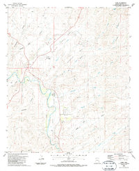
1986 Map of York
USGS Topo · Published 1987About this map
The Gila River corridor defines this portion of the York Valley, where the river’s path is closely followed by the Southern Pacific railroad line. The settlement of York serves as a small hub along the tracks, near infrastructure such as a water tank and a localized Trailer Park. To the north, the junction at Three Way marks a point of transit, situated near the Clifton-Morenci Airport and a Drive-in Theater.
Find a feature on this map
37 named features on this map. Tap any name to fly to it.
Don’t see what you’re looking for? This feature index may not catch every label — zoom into the map to look around manually.
Map Details
Editions of this 1986 York Map
This is the sole edition of this map. No revisions or reprints were ever made.
Other maps of this area

1902 · Clifton
USGS Topo · 1:62,500

1913 · Morenci
USGS Topo · 1:125,000

1915 · Morenci
USGS Topo · 1:125,000

1954 · Silver City
USGS Topo · 1:250,000

1954 · Clifton
USGS Topo · 1:250,000

1957 · Clifton
USGS Topo · 1:250,000

1958 · Silver City
USGS Topo · 1:250,000

1958 · Clifton
USGS Topo · 1:250,000

1959 · York Valley
USGS Topo · 1:62,500

1960 · Guthrie
USGS Topo · 1:62,500