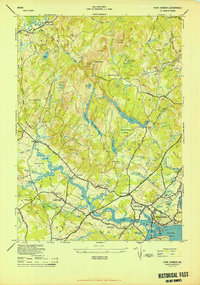
1944 Map of York Harbor
USGS Topo · Published 1944About this map
York Village and York Corner serve as the primary hubs of this coastal Maine landscape during the mid-1940s. The region is defined by a series of prominent rises including Mt Agamenticus, topped by a Fire Tower Agamenticus, and the surrounding hills of Yorkwoods and Horse Hills. Settlement patterns follow the winding course of the York River, where historical landmarks like the McIntire Garrison and Brickyard Landing speak to centuries of colonial and early American residency.
Find a feature on this map
85 named features on this map. Tap any name to fly to it.
Don’t see what you’re looking for? This feature index may not catch every label — zoom into the map to look around manually.
Map Details
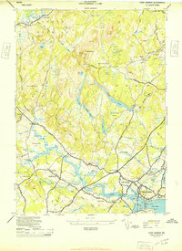
Editions of this 1944 York Harbor Map
2 editions found
Other maps of this area

1891 · Berwick
USGS Topo · 1:62,500

1891 · Kennebunk
USGS Topo · 1:62,500

1893 · Kennebunk
USGS Topo · 1:62,500

1893 · Dover
USGS Topo · 1:62,500

1893 · Berwick
USGS Topo · 1:62,500

1893 · York
USGS Topo · 1:62,500

1898 · Kennebunk
USGS Topo · 1:62,500

1916 · Dover
USGS Topo · 1:62,500

1918 · Dover
USGS Topo · 1:62,500

1920 · York
USGS Topo · 1:62,500