1944 Map of York Harbor
USGS Topo · Published 1944About this map
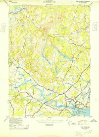
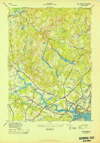
Mt Agamenticus anchors the interior of this coastal Maine landscape, providing a topographical focal point for the surrounding network of hills and water bodies. This 1944 survey, compiled from 1943 air photographs, details the early 20th-century settlement patterns of York Harbor and its surrounding villages. Notable historical sites like the McIntire Garrison and family-named landmarks such as Barrell Farm highlight the deep-rooted local history. The map traces the winding York River as it passes Scotland and flows toward the harbor, flanked by numerous small communities like York Village and York Corner. Coastal landmarks, including Fort Pt and Stage Neck, define the maritime edge of the sheet, while inland, a system of schools like Brixtons School and Beach Ridge School served the rural population. The land use is defined by a mix of wooded ridges like Horse Hills and low-lying areas such as George Hooper Swamp, connected by a web of named roads including the Post Road.
Find a feature on this map
100 named features on this map. Tap any name to fly to it.
Don’t see what you’re looking for? This feature index may not catch every label — zoom into the map to look around manually.
Map Details
Editions of this 1944 York Harbor Map
2 editions found
Other maps of this area

1891 · Berwick
USGS Topo · 1:62,500

1891 · Kennebunk
USGS Topo · 1:62,500

1893 · Kennebunk
USGS Topo · 1:62,500

1893 · Dover
USGS Topo · 1:62,500

1893 · Berwick
USGS Topo · 1:62,500

1893 · York
USGS Topo · 1:62,500

1898 · Kennebunk
USGS Topo · 1:62,500

1916 · Dover
USGS Topo · 1:62,500

1918 · Dover
USGS Topo · 1:62,500

1920 · York
USGS Topo · 1:62,500