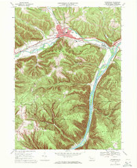
1969 Map of Youngsville
USGS Topo · Published 1971About this map
Youngsville sits at the northern heart of this landscape, where Brokenstraw Creek meets several tributaries, including Matthews Run and Indian Camp Run. The settlement patterns here show a mix of institutional and industrial activity, evidenced by the County Home and Hospital and the nearby Sewage Disposal plant. An active Oil Field north of the village and numerous Oil Wells scattered near Irvine point to the region's long-standing connection to Pennsylvania's petroleum history.
Find a feature on this map
41 named features on this map. Tap any name to fly to it.
Don’t see what you’re looking for? This feature index may not catch every label — zoom into the map to look around manually.
Map Details
Editions of this 1969 Youngsville Map
4 editions found
Other maps of this area

1906 · Warren
USGS Topo · 1:62,500

1907 · Warren
USGS Topo · 1:62,500

1908 · Warren
USGS Topo · 1:62,500

1926 · Youngsville
USGS Topo · 1:62,500

1927 · Tidioute
USGS Topo · 1:48,000

1929 · Youngsville
USGS Topo · 1:62,500

1930 · Tidioute
USGS Topo · 1:62,500

1935 · Sheffield
USGS Topo · 1:48,000

1941 · Sheffield
USGS Topo · 1:62,500

1943 · Youngsville
USGS Topo · 1:62,500