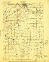
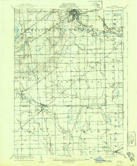
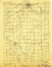
1906 Map of Ypsilanti
USGS Topo · Published 1920About this map
Ypsilanti serves as the focal point of this regional study, which illustrates the complex intersection of early 20th-century steam and electric rail lines. The Detroit Ypsilanti Ann Arbor and Jackson Electric R R cuts across the northern landscape, reflecting a time when interurban trolleys connected Michigan’s growing towns. To the south, the Michigan Central R R and Ann Arbor R R define the corridors of trade and transit, passing through smaller communities like Milan and Azalia.
Find a feature on this map
44 named features on this map. Tap any name to fly to it.
Don’t see what you’re looking for? This feature index may not catch every label — zoom into the map to look around manually.
Map Details
Editions of this 1906 Ypsilanti Map
3 editions found
Other maps of this area

1902 · South Lyon
USGS Topo · 1:62,500

1902 · Ypsilanti
USGS Topo · 1:62,500

1902 · Dexter
USGS Topo · 1:62,500

1904 · Ann Arbor
USGS Topo · 1:125,000

1905 · Wayne
USGS Topo · 1:62,500
1906 · Ypsilanti
USGS Topo · 1:62,500

1906 · Dexter
USGS Topo · 1:62,500

1906 · Saline
USGS Topo · 1:62,500

1906 · South Lyon
USGS Topo · 1:62,500

1906 · Romulus
USGS Topo · 1:62,500
Featured Places
- Ann Arbor, MI
- Ypsilanti Charter Township, MI
- Pittsfield Charter Township, MI
- Van Buren Charter Township, MI
- Ypsilanti, MI