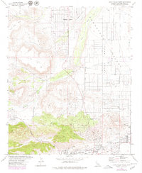
1972 Map of Yucca Valley North
USGS Topo · Published 1979About this map
Flamingo Heights and the northern outskirts of Yucca Valley sit at the desert floor where the High Desert meets the rising geological formations of Black Lava Butte and Flat Top. This 1970s landscape reveals the transition from isolated ranching outposts to established communities, featuring local landmarks like Desert Christ Park and the Yucca Valley Airport. The drainage patterns of Pipes Wash and Chaparrosa Wash are prominent, cutting through the Homestead Mesa to the east. Local history researchers can trace the early road network, including Pioneer Road and Skyline Ranch Road, which connected the various enclaves like Pioneertown to the central valley. The map also identifies specific sites such as a Drive-in Theater and The Windmill, reflecting the unique mid-century character of this San Bernardino County region.
Find a feature on this map
33 named features on this map. Tap any name to fly to it.
Don’t see what you’re looking for? This feature index may not catch every label — zoom into the map to look around manually.
Map Details
Editions of this 1972 Yucca Valley North Map
4 editions found
Other maps of this area

1901 · Southern California Sheet No. 1
USGS Topo · 1:250,000

1902 · San Gorgonio
USGS Topo · 1:125,000

1904 · Southern California Sheet No. 1
USGS Topo · 1:250,000

1953 · San Bernardino
USGS Topo · 1:250,000

1955 · Goat Mountain
USGS Topo · 1:24,000

1955 · Old Woman Springs
USGS Topo · 1:62,500

1955 · Emerson Lake
USGS Topo · 1:62,500

1955 · Morongo Valley
USGS Topo · 1:62,500

1955 · Joshua Tree
USGS Topo · 1:62,500

1956 · San Bernardino
USGS Topo · 1:250,000